![](/images/other/stat-length.png)
![Excursión Senderismo Val de Bagnes - Verbier - Ruinettes via les Shlérondes - Photo](https://media.geolcdn.com/t/1900/400/ext.pjpeg?maxdim=2&url=https%3A%2F%2Fstatic1.geolcdn.com%2Fsiteimages%2Fupload%2Ffiles%2F1553511878bg_sport_marche.png)
Verbier - Ruinettes via les Shlérondes
verbier
Usuario
![Longitud](/images/other/stat-length.png)
![Altitud máxima](https://static1.geolcdn.com/siteimages/upload/files/1508320355ic_sort_altitude_max_24dp.png)
![Desnivel positivo](https://static1.geolcdn.com/siteimages/upload/files/1508320355ic_sort_den_pos_24dp.png)
![Km-Effort](/images/other/stat-length.png)
![Altitud mínima](https://static1.geolcdn.com/siteimages/upload/files/1508320355ic_sort_altitude_min_24dp.png)
![Desnivel negativo](https://static1.geolcdn.com/siteimages/upload/files/1508320355ic_sort_den_neg_24dp.png)
![Boucle](https://static1.geolcdn.com/siteimages/upload/files/16400158638029165_repeat_loop_refresh_sync_direction_icon.png)
![Senderismo](https://static1.geolcdn.com/sitytour/trail-icons/101.png)
5h30
Dificultad : Desconocido
![Escanee este código QR para abrir la excursión en la aplicación SityTrail](https://capi.geolives.com/qq0zvz2zws4bq2lad0pu/sitytour/trails/43048/qr.png?size=200)
Aplicación GPS de excursión GRATIS
A propósito
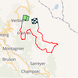
Ruta Senderismo de 10,7 km a descubrir en Vallés, Entremont, Val de Bagnes. Esta ruta ha sido propuesta por verbier.
Descripción
Ausgangspunkt der Wanderung ist die Talstation des Médran-Kabinenlilfts. Den Parkplatz Richtung Hotel Verbier Lodge überqueren und weiter bis la Dent (35 Min.). Bei der Kreuzung zum kleinen Weiler Clambin (25 Min.) bergan Richtung le Hattey (20 Min.) weitergehen. Im Wald dem Pfad bis zu einem befahrbaren Weg (25 Min.) folgen und dann weiter Richtung Shlérondes (30 Min.). Von dort geht es zur Levron-Suone (50 Min.) und dann der Su-one entlang bis les Ruinettes (45 Min.).
Localización
Comentarios
Excursiones cerca
![Excursión A pie Val de Bagnes - Vollèges - Levron - Photo](https://media.geolcdn.com/t/375/260/000ad3aa-b35f-4d3f-9d12-9568cd1e719d.jpeg&format=jpg&maxdim=2)
![A pie A pie](https://static1.geolcdn.com/sitytour/trail-icons/100.png)
A pie
![](/images/other/stat-length.png)
![](https://static1.geolcdn.com/siteimages/upload/files/16400158638029165_repeat_loop_refresh_sync_direction_icon.png)
![Excursión A pie Val de Bagnes - Ancien Bisse du Levron - Photo](https://media.geolcdn.com/t/375/260/80610014-2440-48cc-bb45-b16896750006.jpeg&format=jpg&maxdim=2)
![A pie A pie](https://static1.geolcdn.com/sitytour/trail-icons/100.png)
A pie
![](/images/other/stat-length.png)
![](https://static1.geolcdn.com/siteimages/upload/files/16400158638029165_repeat_loop_refresh_sync_direction_icon.png)
![Excursión Senderismo Val de Bagnes - La Haute Route : J2 - Photo](https://media.geolcdn.com/t/375/260/180b2b28-d72b-4e1f-bcdd-fa58e937cbf2.jpg&format=jpg&maxdim=2)
![Senderismo Senderismo](https://static1.geolcdn.com/sitytour/trail-icons/101.png)
Senderismo
![](/images/other/stat-length.png)
![](https://static1.geolcdn.com/siteimages/upload/files/16400158638029165_repeat_loop_refresh_sync_direction_icon.png)
![Excursión A pie Val de Bagnes - Promenade de la Dranse - Photo](https://media.geolcdn.com/t/375/260/086adfed-46f4-4991-8417-75cd394f8ae1.jpeg&format=jpg&maxdim=2)
![A pie A pie](https://static1.geolcdn.com/sitytour/trail-icons/100.png)
A pie
![](/images/other/stat-length.png)
![](https://static1.geolcdn.com/siteimages/upload/files/16400158638029165_repeat_loop_refresh_sync_direction_icon.png)
![Excursión A pie Val de Bagnes - Bruson - Moay - Photo](https://media.geolcdn.com/t/375/260/086adfed-46f4-4991-8417-75cd394f8ae1.jpeg&format=jpg&maxdim=2)
![A pie A pie](https://static1.geolcdn.com/sitytour/trail-icons/100.png)
A pie
![](/images/other/stat-length.png)
![](https://static1.geolcdn.com/siteimages/upload/files/16400158638029165_repeat_loop_refresh_sync_direction_icon.png)
![Excursión Senderismo Riddes - Croix de Coeur - Pierre Avoi - Photo](https://media.geolcdn.com/t/375/260/ext.jpg?maxdim=2&url=https%3A%2F%2Fstatic1.geolcdn.com%2Fsiteimages%2Fupload%2Ffiles%2F1553511878bg_sport_marche.png)
![Senderismo Senderismo](https://static1.geolcdn.com/sitytour/trail-icons/101.png)
Senderismo
![](/images/other/stat-length.png)
![](https://static1.geolcdn.com/siteimages/upload/files/16400158638029165_repeat_loop_refresh_sync_direction_icon.png)
![Excursión sport Saxon - 20240908 Pierre Avoi - Photo](https://media.geolcdn.com/t/375/260/5bba428f-c7b9-472b-b82a-b07660ccfbf1.jpg&format=jpg&maxdim=2)
sport
![](/images/other/stat-length.png)
![](https://static1.geolcdn.com/siteimages/upload/files/16400158638029165_repeat_loop_refresh_sync_direction_icon.png)
![Excursión Senderismo Orsières - M’ont Brûlé 2 - Photo](https://media.geolcdn.com/t/375/260/6d38f9e3-4aa2-4624-9391-a2cec3e0896a.jpg&format=jpg&maxdim=2)
![Senderismo Senderismo](https://static1.geolcdn.com/sitytour/trail-icons/101.png)
Senderismo
![](/images/other/stat-length.png)
![](https://static1.geolcdn.com/siteimages/upload/files/16400158638029165_repeat_loop_refresh_sync_direction_icon.png)